
Part 1
Let’s just not talk about the flight, shall we? I mean, unless you are 5’2, 80 lbs., and are sitting next to equally tiny people, you’re going to be miserable for most of the 11-15 hours you are on the plane. One recommendation though? Bose over-the-ear headphones. Yeah, they’re expensive. That cranky baby two rows up? That three-year-old to your left? The fidgety 12-year-old behind you? Noise cancelling helps. A lot. Duct tape to keep the brat from kicking the back of your seat would help as well, but I’m pretty sure that’s illegal.
But after that miserable 12 hour flight, you see the “fasten seat belts” sign click on and the plane starts to descend. Out the window is still just blue with puffs of white, that vast expanse of Pacific, and you look for that tiny dot that once drew ancient people in dugout boats in search of a god.
As you make the final approach, if you are lucky like I was my first time, there will be someone whispering in your ear: “don’t be disappointed.”
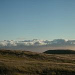
You’re expecting, well, Hawai’i. (You’re close enough, so “when in Rome.” The “w” is pronounced as a “v” and the apostrophe is important. Ha-Vai-E.) You’re expecting lush and tropical. You’re expecting a riot of greens doing a tango with the blues of the Pacific…and as you fly into Kona International Airport, you get a cracked, black wasteland, something out of a scorched earth sci-fi film.
The island of Hawai’i (called the Big Island to avoid confusion) is the youngest of the islands, and the largest—nearly twice as big as all of the other islands combined. You fly in over the lava fields, a barren expanse of black rock that hasn’t been ground down into sand and soil yet—give it a few more million years. It is also on the dry side of the island. On every island, you have a dry side and wet side, or leeward and windward. Technically, you are flying into a desert. The Big Island sports all but two of the world’s climatic zones. Great one to start with, huh?
Hawai’i, and the spirit of the Big Island, is apparent as soon as you step off the plane. Literally. As-soon-as-you-step-off-the-plane. KOA is the only outdoor international airport in the world, and the only airport on the Hawaiian Islands that use a mobile ramp. You deplane onto the tarmac and walk towards a collection of single story, open air structures.
Desert or not, the cool winds wrap around you. Warm, but not too warm. The year round temperature (not the average, but every day) is a high between 78 and 85. With the cracked black earth hidden from view behind waving palm trees and car rental lots, your vacation begins. Welcome to Hawai’i. Aloha.
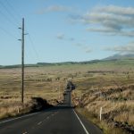
The airport is built on the western side of the island, about midway, on a two hundred year old lava flow. The airport exit road dumps you onto one of the three major highways on the island, Route 19. A right hand turn will take you south into Kailua-Kona, one of the two population centers on the island and the biggest tourist area. With a quick 20 minute drive along the two lane highway, that opens up into one of the few four lane stretches on the island, you’ll be among the condos and K-Marts, Cosco to the left and the touristy Alii drive to the right. We’ll start left, though, and travel up through those barren lava fields.
–Stop. Reality break. That airport exit road? How you feel about that road determines whether or not a trip to the Big Island is right for you. You just rented a car (Minivan or SUV if you have more than two people), stuffed a week’s worth of luggage and family members into it, and now you are at a red light, staring off into a distance that makes you question the use of the word “island.” This ain’t Bermuda, or even Oahu. To truly experience the Big Island, you’ll come to appreciate the “unlimited mileage” on the rental. The Big Island is about the size of Connecticut. It is like if you wanted to see all of New Jersey so you rented a hotel room in Philadelphia and took day trips to various points. One hour here, two and half hours there, etc. A circuit around the entire island takes about 5 hours. Even a trip to the beach, unless you are staying at a resort, will take a nice drive.
To me, it’s more than worth it, but I love to drive, and the scenery is just amazing. A two hour drive passes quickly when you are mesmerized by the beauty. But now it is time to push reality away again, and get back to that red light at the end of the airport exit road. Right lies your rented condo or house, but we’ll turn left….
Spectacular views of volcanoes rising in the distance will great us, along with an ever present cloud bank seemingly stopped at the volcano range. Cracked black earth rolls gently up and away into hills and the saddle between the two dominant volcanoes.
If you are not too jet lagged (I returned later), you can start your exploration about two miles north on the right hand side, where a gaping hole sits right next to the highway. Just pull over and park. It is the end of a lava tube that you could once travel all the way up into the hills. I went about 50 yards in and then clambered up the colapsed roof. To the left of the highway is much more of the same, though dotted with palm trees every so often at the edge of the ocean—those palm trees mark a secluded beach if you are up for the hike. About 20 miles north, you’ll get to, well, Australia.
Part 2
In geological terms, The Big Island is still a baby. It’s older brothers and sisters have long since stopped suckling at the hot spot that formed them and shifted north with the plates. If man had not come with their machines, much of the dryer side of the island would be like what you are driving through now along Route 19, Queen Ka’ahumana Highway: lava fields with wispy Egyptian grass and a scattering of the hardier trees.
But man will do what he does when he sees a desolate space: he’ll build a mall. You need something around the mall, so you get the condos and golf courses, pools and parking lots. What you really need before you start building anything, though, is dirt. The Big Island is in short supply of the stuff, so it was imported from Australia. There is probably enough of the stuff for Australia to make a claim.
Stretched along the border between North Kona District and South Kohala District, and wedged in between the ocean and Queen Ka’ahumanu Highway, is the Kohala mega resort area. It is hard for me to write about it because, well, I’m a snob. It is as if they took a largish upper crust town (or smaller city) and plopped it into paradise. It’s huge. There are two malls, a few golf courses, villas, both a Hilton and a Marriott, and the amount of condos makes me think of those enormous ant hills rising out of an African plain.
If I can push aside my bias against the crush of people, and be fair, I have to say this: it is nice. The resort area has been sculpted and it is beautiful. If your idea of a vacation leans more to the resort with all of its amenities, this is the place to be, with some of the world’s best beaches close by and tour busses that will take you anywhere on the island. I enjoyed one of the golf courses and the girls loved the shops and outdoor malls.
Just a bit north of here is a must stop: Hapuna Beach. It is a crescent beach, a half mile long and 200 feet wide, wrapping away from the Mauna Kea Beach Hotel. Okay, okay: I don’t get all googly eyed over beaches, but I did marry a beach girl raised in the sand and surf. Tracy says, and everyone agrees, including Conde Nast Traveler, that this is one of the best beaches in the world. It has even been listed as THE best in the United States. Me? Well, it’s a beach. Nice sand, azure water, great snorkeling, and excellent amenities including a snack shack, great changing and showering facilities, good parking, and easy access. On a clear day, you can see Maui in the distance. (Insert Palin joke.)
After passing Hapuna Beach, it’s time to let the family fall asleep and just enjoy the drive further north. We usually stay down south in Kona, in a house or condo, so this long stretch of road that curves slightly is an old friend. It is my second most favorite drive in the world, but is the most—for lack of a better word—comfortable. Traffic is sparse and I can steal glances at the Pacific Ocean away to my left and ancient lava flows to my right that gently climb up towards mountains and that ever present wall of clouds.
–A word about speed limits. Along this stretch, the posted speed limit is 55, which to me means “have at it” and could be replaced with the shaka symbol—that pinkie-thumb wave you’ll see everywhere. After you drive the island for a while, though, you realize that the other posted speed limit signs are not arbitrary like they feel at home. They mean it, and it is for your own safety. If the sign says 25, it can be translated as: “go 25 mph or risk flipping your car down a mountain and ending your vacation in a fiery ball of death.” So, be careful!
A couple miles north of Hapuna Beach is the intersection of Route 19 and Route 270 (Akoni Pule Highway). If you turn right to follow Route 19, you’ll be heading east towards Hilo, but I have to say a few words about my “shortcuts.”
Directly across from the resort is the beginning of the Waikoloa Road that snakes up into the high country, passing through Waikaloa Village, and ending at Route 190. I think of Route 190 (Mamalahoa Highway) as the mountain alternative to Queen Ka’ahumanu Highway, the coastal highway. Starting down in Kona, you drive up along ridges, bypassing the airport, and eventually connect with The Saddle Road, Route 200 (that I’ll be getting into later). It ends in another town, Waimea, at Route 19. “Longcuts” might be a better way to describe the roads, but they each offer unique perspectives on the island.
We’re leaving Route 19 behind us for a while as we turn left and follow Route 270. The land begins to change as you begin to move from the dry side of the island to the wet side. Patches of green begin to shove aside the brown and black. Soon, it is the black you see in patches and brown dominates.
With Hawi and Kapa’au anchoring the north, tiny towns dot this area of the island. They were devastated when big sugar left a few decades ago but are making a comeback as artist communities where you can buy local arts and crafts. There are also tour stops with zip line tours, mini-excursions off the beaten path, and there was a boat ride through the sugar canals that I have not gotten to yet. If you see a guy on the side of the road selling “fresh cut, white pineapple,” stop and buy some—it’s delicious and unlike anything you have ever eaten.
A few miles east past Kapa’au, Route 270 ends. No turnabout. No parking lot. I’m not even sure if there is a stop sign.
One of the things I find amazing about the Big Island is the “end of the earth” feeling that you get from a few different spots. Land just falls away into the sea and you can just imagine that the horizon really is the edge of the world. Pololu Valley is one of those spots.
The overlook is magnificent, but if you walk down a few turns of the switchback trail, the view is even more amazing. It is as if the earth folded in on itself and you are staring down into the fold. Most people have seen Pololu Valley, but don’t realize it. The opening sequence to Jurassic Park, where the helicopter drifts down into an immense gorge? Yep, that’s it.
The trail takes you along a zig zag down the side of the cliff. It’s easy going for the most part, but I wouldn’t pick up too much speed. There are no guard rails or stairs and it really is a long way down (about 400 feet). Tracy made me walk in front of her so that if I went over I wouldn’t take her out with me.
You descend into an ancient valley where a watershed meets a black sand beach. It is a narrow crescent, only a yard or two wide at best, of the black sand (ground lava rock). In between the land and the sand is a strip of rocks ten yards wide. You are standing on sacred ground.
I’m going to throw some Hawaiian history at you here because I think it’s pretty cool. About 25 miles down the road where we came from, right past where we split from Route 19, is the Pu’ukohola Heiau. A heiau is a temple made of the kind of rocks founds along the valley. King Kamehameha was told that if he built a great heiau to his war god, he would conquer all of the Hawaiian Islands (he was the first to do it). The rocks had to be carried from this valley. Not only did the rocks have to come from this valley, but they could not touch the ground until they rested on the site of the temple. From 1790 to 1791, there was a 25 mile long chain of people handing each other rocks, some as much as 75 pounds.
On the Big Island, what goes down must come back up. Like many places here, you have to really, really, really enjoy it while you are there. You look up that 400 foot cliff, know that your car is somewhere up there, and you start what I think of as the Hawaiian trudge: that purposeful, thigh-hurting, shlepp up cliffs and valleys to get you back to your car and on to your next destination. Aye, at least you’re not carrying a 75 pound rock.
By the way: the Hawaiian words? I’m copying them from a guide book. Tracy gets pretty disgusted with me when I try to pronounce them so I will never read this piece out loud. According to her, who grew up here, they sound exactly as they are spelled (with some rules). I love to ask her what the state fish is, it just rolls off of her tongue: Humukumunukunukuapua’a.

Part 3
From Pololu Valley, we are going to have to backtrack along Route 270. The road really does just end. The end of the road turns into the beginning of the road and you make your way back down to Hawi.
–-seriously, stop and buy some of that fresh cut, white pineapple—
You might also want to stop in Kapa’au or Hawi and stock up for the next leg of the journey. I stopped for a cup of coffee and ended up sitting there for an hour or two while the girls went from shop to shop to shop to shop…good coffee though.
As you wander through their stores, sometimes just the bottom floor of their houses, a word about how you deal with the locals, both the natives and the ex-pats who now call the Big Island home: be nice to them! I spoke to a couple fellow travelers who said they felt a distance or even coldness from the locals. I got the briefest hints of it. Me being me, however, I smiled, looked them in the eye, and just tried to be pleasant whether I was asking for a cup of coffee or the way to the driving range. Being warm and polite can go a long way.
In Hawi, we’ll be making a left onto what seems like a side street, just an innocuous looking path between two houses. It is actually the beginning (or end) of Route 250, Kohala Mountain Road.
Anywhere on the island, your eyes are drawn to the two main peaks, Mauna Kea and Mauna Loa. The Big Island is actually made up of five volcanoes—with a sixth still under water off the southeast coast. Kohala is the oldest. It last erupted about 60,000 years ago and is considered extinct. Being the oldest, it is also the lowest in stature, with the peak about 5,505 feet. Route 250 follows the spine, or saddle, between Mauna Kohala and Mauna Kea.
There are some fantastic views as you travel the 20 miles southeast towards Waimea. I remember long stretches of tunnel, where the trees made a canopy overhead. There were breaks in the tree line where the land just fell away into valleys. If you look back the way you came, it seems as if a huge mountain is hovering over Hawi—it is Maui off in the distance. The road crests at 3,564 feet and then you are heading down into Waimea, into the heart of cattle country.
Yep: cattle. Beef, longhorns, and yet another word that annoys my wife when I try to pronounce it as I can never seem to get it right: paniolo (Tracy: “just call them Hawaiian cowboys!”). All along 250, and down Route 190 towards Kona, is the original Parker Ranch, once the largest privately owned ranch in the United States at 225,000 acres. Texas can shake a stick at that. There is still a rich tradition that merges the cowboy way with Hawaiian culture and the Mexican cowboys who came over in the early 1800’s to teach the locals ranching. If this is your thing, The Parker Ranch Visitor Center is right by the intersection of Routes 19 and 190 in Waimea.
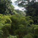
But we’ll be driving east from the heart of cattle country into what I feel is the heart of the Hawai’i you were expecting when you flew in over those black, cracked lava fields. Though you are still on Route 19 (we took a left when 250 ended), it is now called the (New) Mamalahoha Highway, or the Hawaiian Belt Road. As you travel due east, and then south, you leave scraggly lava fields and immense pastures behind and travel to the wet, or windward, side of the island.
That lush, fertile tropical land speckled with waterfalls that you were expecting? Here it is, and it is glorious. You drive through folds of the earth. It is as if you drew lines on a blanket spread out flat over your bed, and then you bunched it up and crumpled the blanket to leave it in a pile in the center. Essentially, that’s the Big Island of Hawai’i with the uncovered area of your bed the Pacific Ocean. The lines you drew would now be dipping into the crevices and wrapping up through the valleys and gorges you created. Switchbacks and tight turns are as common as bridges, so pay attention to those speed limit signs. Changes in elevation can be as dramatic as the scenery.
It is just a spectacular drive with the ocean to one side and mountain to the other (Mauna Kea). Many consider this the best drive on the island; I consider it the best drive in the world. If you are driving to “destination” points, it is easy to bypass this drive because other routes will get you there faster. But it will truly be your loss.
When I arrived in Hawai’i, I wanted to see two things: topless women in grass skirts doing the hula (aye, I’m male and at 44 making it through puberty is still just a hope) and tropical waterfalls. The former was never going to happen, but the later is plentiful on the northeast coast.
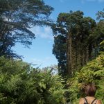
Akaka Falls (one of many but one of the most popular) should not be missed. It is about 3 ½ miles off the main road north of Hilo. The first thing that popped into my head when I saw it was God’s ice cream scooper, as if He scooped out a side of a mountain, leaving a 420 foot waterfall behind. There is a ½ mile paved loop that will take you to the falls. Lots of steps. Lots and lots and lots of steps. You’ll walk through a bamboo rain forest over rivers and streams to end with the magnificent view of Akaka Falls. (If you are in a hurry, and aren’t into the Hawaiian Trudge, there is a quicker way to the falls if you turn left instead of doing the entire loop.)
And then you are down into Hilo, as much of a city as you will find on the Big Island. There is probably a whole bunch of stuff to write here, and a whole bunch of stuff that I missed driving down the Hamakua Coast: the capitol, more waterfalls, the east end of the Saddle Road, state parks, beaches, botanical gardens, etc. But, well, it’s just not my thing.
My time on the Big Island is always limited. Hilo is carved out of a tropical rain forest, and “rain” isn’t an affectation. Hilo is the rainiest city in the United States—look it up: it makes Seattle look like Vegas. And, well, it’s a city. I don’t like cities on vacation. Stop lights? Rush hour? Am I showing my snobbiness again?
We’ll stop for a meal (hello Auntie and Uncle!), and then continue on our way. Highway 11 beckons, down towards Volcanoes National Park…


Part 4
Two scoops of rice, one scoop of macaroni salad, and, well, stuff. The “stuff” can be anything from fried mahi mahi to chicken katsu, a blend of the many ethnicities that call Hawai’i home. That’s the Hawaiian plate lunch: fast food, aloha style. Volcanoes National Park makes me think of food because the first time we went there, we did not have any and the on-site restaurant was closed for renovations. My family has blood sugar issues; they need to be fed on a regular basis or you get something out of The Exorcist. You would be thinking about food as well.
The park can be a day trip or a week long adventure for the camping/biking enthusiasts. About thirty miles south of Hilo (or ninety miles from Kona—my normal route), the park is all about Kilauea Volcano, the most active volcano in the world, and one of the five that make up the big island. It is also considered one of the most “user-friendly” volcanoes. To really appreciate the park, give yourself, at the very least, the day, bring plenty of snacks (maybe a plate lunch), good walking/hiking shoes, and a pull-over (it can be chilly and misty at times in some areas). What you will have to leave behind is any Creationist Theories that you might have.
Creationists believe that the earth was formed 6,000 years ago. It’s a bible thing, calculating all of the “begats” in the old testament. Here, the science of geology is king, and the king bears no fools. Even if you are like me, and have absolutely no interest in geology, you still become a geology geek at the park. How can you not when new land is being created in front of you?
The Big Island is not only the biggest of the Hawaiian Islands, it is growing bigger. Each day, between 300,000 to 1,000,000 cubic yards of lava erupts. Since 1983 (when this current eruption began), 475 acres of land have been created.
One perspective is that you are on an island. Another perspective is you are traveling the Alps of the Pacific, though the actual Alps are puny in comparison. About three miles below sea level is the hot spot that forms the chain, about 137 islands. The islands are actually the exposed peaks of the Hawaiian-Emperor seamount chain, moving northwest with the Pacific plate at about 32 miles per million years. The Big Island is the baby brother of the chain, about 400,000 years old with a peak (Mauna Kea) of 13,796 feet. The oldest main island (Kaua’i) is about 5.1 million years old with a peak of 5,243 feet. More reef than land, and about 1400 miles from Hilo, is Kure Atoll, the oldest at 28 million years. See why I just smack my head when I think of creationists?
But to the park…
We’re going to be conventional and start at the beginning, at the visitor center. It is where the geekiness begins to build. From my guide book: ““Despite the fact that it is operated by the federal government, the park seems very well run.” The rangers and staff are excellent and the visitor center is their main stage. Ask them anything. Their knowledge, and their excitement at answering the questions, really impressed me. The visitor center also sports plenty of maps, pictures, a souvenir shop, a small movie theatre and plenty of displays to start teasing the geology geek.
From the visitor center, we’ll drive west along Crater Rim Drive. And I’m pretty upset about this. I didn’t want to. I like the symmetry of a clockwise tour around the island and a clockwise tour of the park, with the visitor center the last stop. But then some idiots ruined it for everybody.
From what I heard, Crater Rim Drive is completely passable for the entire circuit. Recent volcanic activity, however, has forced the rangers to close the southwest portion of the road. Why? Because of idiots. There are poisonous gases. As long as you stayed in your car with the windows up and the AC on, you were fine. But the rangers kept finding the nitwits that just had to get out of their cars to look at something. I don’t think there were too many deaths, and I sort of like the entire “Darwinism at work” aspect, but someone probably sued somebody.
But the next stop is still a nice introduction to the park. We’ll pass the steam vents and arrive at a “destination.” Grouped together is the Hawaiian Volcano Observatory, Jagger Museum and Kilauea Overlook. You’ll find some great displays at the observatory and museum, and more of those awesome park rangers. The overlook is what has been bringing dignitaries and us normal people for hundreds of years: a panoramic view of Kilauea Caldera and Halema’uma’u Crater, the later being the home of Pele, the volcano goddess. Things are fairly quiet now, but Mark Twain saw a bubbling inferno.
Soak it in, enjoy the sights, have a seat and relax because, next, there is some hiking to do.

We’ll do the backtrack boogie past the steam vents and the visitor center, clockwise along Crater Rim Drive. When you see all of the tour buses, park. On one side is Kilauea Iki Overlook but we’ll continue with the appetizer portion of the tour and start on the other side: Thurston Lava Tube.
It is a few minute walk down into a bowl of tropical rainforest. It is probably no bigger than a 3,500 square foot, three story house. You start in at the “attic” and wind your way down. A well lit, round opening awaits: welcome to the plumbing of the volcano, Thurston Lava Tube. It is easily 10 feet high with smooth walls and floor. The lava tube has been cleaned up of debris and stalactites (unlike the lava tube I clambered into in part 1), but it is an interesting walk. An underground lava flow created this tube, and hundreds like it. It makes me think of lava as an enormous earthworm, burrowing its way through the ground, leaving a hole behind it.
At a crevice in the ground where you see daylight above you, you have the choice to join the large group of tourists going up the ramp and steps, or you can break out your smart phone made flashlight and descend into the rest of the lava tube that has not been cleaned up for tourists. It’s eerie. Once you walk about 100 yards, the light from the opening is gone and it’s just you and that portable battery. The lava tube ends abruptly about 1,000 feet in.
Flick off the lights. The darkness is absolute. Reality seems muffled. You may even lose any sort of spacial orientation so walls, ceiling and floor all seem the same as you “hang” in space. The moist, coolness of the tube is your only sensory input and the absence enfolds you.
Until the next tourist group stumbles along.
You’ll pop back up into the open air, climb the steps out of the bowl, but don’t even think about getting back into your car. Across the street is what I consider the main course of the tour: Kilauea Iki.


Still have those walking shoes on? Some bottled water? Lunch in your backpack? Pullover? Let’s get started then. The Kilauea Iki Overlook is the starting point (and ending) for one of the best hikes on the island. It is a three mile hike that will take you around the rim of the crater, down into it, across, and then back up here. I wouldn’t call it an easy hike, but it isn’t extreme either.
Kilauea Crater is a vast oblong bowl. Tropical rainforest rings the edge and then marches down into devastation. In 1959, what you are looking at was a boiling sea of lava—I called my 14 year-old nephew from inside the bowl and explained that to him and he seemed moderately impressed. The first time here, I just scampered down this side and then came back up, when food was scarce and the family might have had thoughts of cannibalism. The second time, though, I needed to do the entire hike.
It is a well marked trail, rolling gently downward, along the northern edge of the crater. You walk through a variety of plants with overlooks at various stages to catch glimpses of the crater at various angles. On your cell phone, you can call to get recorded messages of what you are looking at. When you get to the western edge, you begin the switchback stage of the hike. It is not as far down as the eastern point, but I remember it being a bit more treacherous. Steps and handrails, though, are there when needed. After 10 minutes or so, you are on the crater floor.
There is a general path down and around, marked, and there will be other groups making their way. The western side is more cracked and difficult, as if the lava spurting had been more violent. You are also still sloping gently downward.
After a certain point, at about 450 feet from the top of the crater, it just opens up into a vast, flat gray stone field, from where the lava lake cooled. Yes, the lava is still down there, as evidenced by the steam vents: rain water collects, drips down, hits the lava a hundred feet below and then hisses back up. (If you get chilly, like my wife did, the steam vents are a good place to get warm.)
We had lunch on one of the outcroppings. It was nice to just sit there and look around. The sharp contrast between the violent, almost sterile devastation around you and the vibrant, tropical wilderness above you is eerily beautiful. Towards the eastern edge, those hardy trees and bushes have begun to sprout, some with bright red blooms, lehua blossoms. I wanted to call them Pele’s Rose, but Tracy wasn’t having any of that, so lehua blossoms they are.
A word of warning: don’t bring back any souvenirs! Leave the lava rocks and lehua blossoms alone or else you’ll piss off Pele, the volcano goddess. You’re hiking through her front porch and she gets pissy when people take things. The state of Hawai’i gets hundreds of pounds of rocks mailed back to them each year from tourists who took something home and their luck turned to crap. Seriously. Be respectful and leave it alone. Or else.
But what goes down…yep, time for the switchbacks again and the Hawaiian Trudge. On the eastern tip, it’s all rainforest, all the way back up, about 450 feet. It is a dirt path, well cleared and traveled, with little chance of falling over the edge. But it is still 450 feet up. For me, this was the hardest part of the hike. My very spry mother-in-law made the trip with a few rest stops. At age *&^%$, she had never done this hike but always wanted to, and she was very proud of herself that she made it.


If Kilauea Iki is the entrée, then Devastation Trail, a mile or so down the road, is the after dinner drink before the dessert. It is a much easier hike, just a 10-15 minute rolling walk through what was once lush forest.
It begins abruptly. One second you are walking in tropical greenery and rich soil and then you are crunching your way along tephra (airborne gas-frothed lava that has cooled as pumice cinders). In 1959, when Kilauea Iki blew, fountains of lava exploded 1,900 feet into the air and it rained fire on this area. This is what was left. It is beautiful in its own unique way, as shades of gray and crunchy pumice are being pushed back by the surrounding forest seeking to reclaim its own.


Ready for the last leg of the tour? Let’s go see the end of the world! Again. Or, in this case, the beginning.
Not too far from the parking lot for Devastation Trail, we’ll come to Chain of Craters Road. If you haven’t figured it out yet, switchbacks and rapid changes in elevation are as much a part of the Big Island as the shaka (that hand thing they do with the pinkie and thumb). You are at about 4,000 feet when you enter the park. In 15-20 minutes down Chain of Craters Road, you’ll be at sea level. It’s a gradually descending, well made road until you pop out of the rain forest onto carved black terraces with an amazing vista of lava fields and—you guessed it—the edge of the world. The road cuts down the side of the volcano along those terraces and tight switchbacks until you make it to the edge of the island. It is a pretty spectacular view up and down.
The road doesn’t stop, but access does. At one time, you could drive back to Route 11, but Pele had other ideas and repaved long stretches in lava. There is now a parking area here with bathrooms and a gift shop. –Snacks too.
A short walk has you looking out over the ocean from the top of a black cliff a couple hundred feet high. It’s shear, from where the lava just folded down over itself, cooled, and stayed. The sights and feelings there are tremendous. That wind pummels you at the cliffs as you stare down at dark blue ocean pounding against the jagged black cliffs that zigzag into the distance. The Holei Sea Arch is one of the more recognizable pictures you will find of this area, where the sea eroded the inner part of the cliff leaving a 300 foot arch.
The actual lava flow is still a few miles away, but don’t get too excited: you’ll never get close enough to see the actual flow. You can walk a couple miles along the closed road, with the wind pushing you every step, but poisonous gases–and top notch rangers–will keep you far enough away so you won’t hurt yourself. The best you can hope for is to see the red glow at night (the park is open 24 hours). You can hear it though, the hissing as molten rock meets crashing waves. Black sands beaches form and then are washed away.
The walk back to your car is the easiest on the island. Enjoy it. There is no Hawaiian Trudge here: just flat, level asphalt with gusting winds at your back, helping you along.


Part 5
As we drive south from Volcanoes National Park along Route 11, there is an entirely different feel. The most southern point in the United States is a lonely place. It is a beautiful drive along the flanks of Mauna Loa, the largest shield volcano on earth. There is a subdued quality to the atmosphere unlike the verdant forests of the northern belt or even the cracked, black lava fields of the western belt. The land seems more quiet as you drive down long swathes of “steps” towards the ocean. It is a comfortable loneliness in the least populated area of the Big Island.
As an East Coast guy, used to multi lane highways, steel forests and a crush of people, it is difficult to write about the southern end of the Big Island. The entire Big Island is so foreign to my normal world, it is like driving into a bubble of space that exists outside of reality. The southern end of the island is like a bubble within a bubble. So it is fitting that the first stop is an opposite reflection of what I am used to: a black sand beach.
I have to put my geological geek badge on for just a moment. The beaches I grew up on (and chased off by the cops) in New Jersey and Florida were like Hapuna and most beaches in the world: white sand. They are organic in origin, crushed up shells and coral. They are replenish able. In Jersey, you even see huge rigs off the coast pumping sand up from the ocean floor to prepare for tourist season. Black sand beaches, though, are inorganic and non-replenishable, which makes them rare. You won’t find them outside of “newer” islands.
There are two kinds of black sand beaches. The black sand beach at Pololu? That kind is created by lava rocks being chipped away by coursing water like the river in Pololu Valley. They can be course, crunchy. Then there are beaches like Punalu’u, called “genuine black sand beaches,” created when a certain kind of lava flow (‘a’a) meets the ocean, solidifies, and then is pulverized by the waves, creating a very fine sand—my feet immediately sunk in up to my ankles as soon as I stepped onto it. Most genuine black sand beaches are quickly washed away which, to me, makes them even more special.
Any first time trip to the Big Island has to include a stop at Punalu’u, the most accessible black sand beach on the island. It is a big tourist attraction, and is also a meeting place for the locals, so the parking lot tends to be full. As soon as you see that black crescent winding away in front of you, the drive and trying to find someplace to park will be worth it. Swimming is allowed, but I wouldn’t put on your trunks just yet. It’s cold (cold fresh water springs feed the bay) and it can be rainy (you are still on the wet side of the island).
If you walk the beach, you might find another local. Sea turtles (honu) are making a comeback from when they were almost hunted to extinction and they love this place. Tracy was telling me that she never saw honu when she lived here. On one of my visits, it was a sunny day and four honu were sunning themselves on the black sand. As I watched (well, gawked with the rest of the tourists), a fifth made its way up through the waves and boulders to join his buddies.
The cold water of the bay kept me out of it, so as the ladies spread out towels and assumed positions much like the honu to take a nap, I went for a walk. Out and away from the black sand beach are black lava shelves pocked with tide pools, perfect for a non-beach person to explore.


About 15 miles south of Punalu’u is Na’alehu, the real southernmost town in the United States. Yes, Key West’ers, we’re about 500 miles south of you–so you can shake a stick at that. Even if you’re not hungry, you have to stop for pie. It is the best pie you’ll ever have, at the aptly described southernmost restaurant in the United States, Hana Hou Cafe.
After pie–and Kona coffee of course–we’ll now be driving west—Route 11 takes a hard turn at Na’alehu. In about five miles, there is the entrance to my favorite place on the Big Island: South Point Road.
South Point Road is different. All of the highways on the Big Island have a relaxed feel, that “so not Philadelphia or anyplace like it feel.” The comfortable loneliness of this area gets pushed to an almost surreal otherworldly point. You are driving to the southernmost (tired of that word yet?) point in the United States, down a relatively thin stretch of land, with constant winds that carry the ocean with them. The road—well paved–is barely wide enough for two cars, with some blind hills and one lane bridges. It sort of reminded me of some roads in Britain, made exclusively for minis.
As you get closer to South Point, wind farms begin framing the landscape. All that is really here is wind and horses. I’ve never seen anything quite like it. The ocean is hidden from you behind low hills, but you know it is there. Herds of horses surround you and thin almost fragile seeming windmills stretch towards a cloudy sky. You are driving towards the end of the world. Again. In eight miles, you are there.
I really enjoyed South Point. As an “attraction,” it does not have much to say for itself, just another piece of land, with tall cliffs, jutting out into shades of blue with gusty winds pulling and pushing you. It has a nice little parking and picnic area, and there will be people diving off the cliffs to climb back up a metal ladder. The thing I enjoyed most about South Point is the perspective.
Think about it. For all that the Big Island is a massive island, it is really just a tiny spec of land in a vast ocean. If you were to dive off this point and swim south, the first thing that you would hit would be Antarctica, 7,500 miles away. I actually looked it up on a map. If you veered a little left or right, you might hit the Cook Islands or French Polynesia. Due south, though, across half the globe, there is nothing waiting for you but the polar bear club. The immensity of it just wraps me up.


If you travel up South Point Road a little way and hang a right, you’ll be on the access road to the Green Sand Beach. Hands down, this was my favorite. Getting there, however, is an adventure in itself.
The first part of the access road is paved, but trouble starts when you get to the parking lot, though calling it a “parking lot” is a bit ambitious. I saw one guy bottom out his rental on a slab of concrete. Bye, bye oil pan; hello major expense.
Bring cash. The green sand beach is about 2 ½ miles away. It can be hiked, and it’s completely free. But it is a grueling five miles. Guidebooks say it is a “deeply rutted” road. That is sort of like calling the Arctic Ocean a “bit chilly.” Some of the ruts are deeper than cars. If a couple of tank divisions had a rugby match in a torrential rain…that gets closer to what it is like.
And it is not a Hawaiian hike. There are no tropical rainforests, no black cracked stone desert, and nothing that I would consider even remotely scenic (many may disagree). It is a red dirt landscape with a constant wind, and dust, and no true marked path. Coves dot the coast. You might not even find the green sand beach.
That’s where the cash comes in. Locals will bring you and your party in their 4×4’s and pick-ups for $15-20 per person. Our guide reminded me of a Hawaiian version of Cheech, and he had my mother-in-law laughing in the cab the whole way there and back. The ride was even fun, diving through valleys, clambering up steep inclines, until we pulled into a parking area where rolled “cigarettes” were being passed around with the other drivers.
Geology time. There are only a handful of known green sand beaches in the world, this one, one on the Galapagos Islands, one in Guam, one in Norway, and possibly one on the Baltic Sea. The sand gets its color from the semi-precious stone olivine, crushed up into a fine sand. It is disgorged from a volcano under an incredible amount of pressure to build up along the edge. But here we are. Yep, you’re about to go swimming in the crater of a volcano.
The sheer walls are cut with steps that bring you to a narrow crescent of fine green sand. The south side of the cone has fallen out to allow the ocean in and the waves were perfect for a swim. Some guide books talk about how dangerous it is, but others say as long as you stay in the bay, and the surf isn’t high, you should be okay. We were, and it was wonderful. We could feel a pull outward, but the next wave just slapped us back in.
Only a handful like it in the world.
If Cheech hadn’t been waiting on us, I probably would have stayed longer and explored the high cliffs that frame the eastern edge of the beach. Tara and I climbed up, but not as far out as I wanted to go.
The view takes your breath away quicker than the wind.


Part 6
The long and winding road. Isn’t that a Beatles’ song? That’s the stretch of road from South Point north towards Kona, about 50-60 miles along Route 11. My only trouble with the drive is that the road is challenging enough (fun) with its turns and cutbacks that I could never get good looks at the views, though I could hear the ladies oooohing and ahhhhhing. The changes in elevation are constant—a five mile stretch can have you going up or down a thousand feet with your ears popping a few times.
–yeah, back to the speed limit signs. Pay attention! Aye, take advantage of the “55” straightaway’s, have at it, but when the things say slow down, slow the hell down! …or else end your vacation in a fiery ball of death–
But we’ve been adventurers and explorers, backpackers and hikers. We’ve tread through ancient valleys and the plumbing of volcanoes. We’ve crunched through the aftermath of geological revolution and saw the earth being made! We’ve braved high winds and cracked, black wastelands. We’ve done the Hawaiian Trudge up 45 story cliffs into tropical rainforests. We’ve gloried in the edge of the world! –three times.
Now, it’s time to be unabashed tourists.
So, kick off the hiking shoes and slip on the black socks with flips flops (really, don’t: it’s just an expression and you look ridiculous). Settle that ratty old hat on your head with the super expensive sunglasses. Sling that camera on your shoulder and the fanny pack around your waist. Let’s do Kona!
What the hell is it called anyway? Kona? Kailua-Kona? Kailua? It all means the same: the end (or beginning) of the circuit. It is the tourist center of the island, where the majority of your vacation dollars will go. There is a saying on the Big Island that all tourism flows west to Kona and all tourism tax revenue flows east to Hilo.
Kona is where my stays on the Big Island usually begin. We rent the minivan at the airport and then drive down into Kona. About five miles south of the airport, the road opens up into a four lane highway (six if you count turning lanes) lined with shopping malls and department stores. We add to the trunk from Cosco and Wal-Mart and then make our way to our rented house or condo.
Tracy does all of the vacation planning. My first time there, she rented us a house up on a hill a little south of Kona. It offered beautiful views of the bay and the sunset. I hate to be quaint, but it really was in the prettiest little neighborhood you’ve ever seen. The next time, we stayed in a condo on the beach. You couldn’t beat the location, right on a private beach, but I preferred the house: traffic makes my teeth itch.
The house or condo became our command post, our center of operations. For this section of the Big Island series, it will serve the same purpose. Your excursions and “sights to see” will depend on your tastes, but I’ll share a few of my own.
…a thought just occurred to me. As we sit and watch the waves roll in from the lanai (Hawaiian porch) and sip on some Kona coffee while the girls are getting ready, I realize I haven’t written anything about what really makes Hawai’i Hawai’i. It is what brings ex-pats to the island even more so than the views and the weather. It is what makes me want to live here. It is aloha.
Most people who are not familiar with Hawai’i think of “aloha” as meaning hello and good-bye. When someone says “aloha” to you, though, they are saying so much more. Its literal translation means “affection, peace, compassion and mercy.” Hawai’i is the “Aloha State” and you will see road signs that say “drive aloha” or “live aloha.” Aloha is a state of mind, a state of being.
–It makes think of Bill and Ted from “Bill and Ted’s Excellent Adventure.” They translated “aloha” to “Be excellent to each other!”—
You get the first hints of it when you deplane onto the tarmac. For a native returning home, like my wife, it is as if she dove off the gangway into a crystal clear pool on a hot day. Her steps become lighter, her smile bigger, and there is just something about her that changes. I always used to think of it as coming back home. Now, however, I think of it as coming back to aloha.
Through the hundreds of miles of highway and the beaches and the volcanoes, I just haven’t thought to write about it because it just is. You’ll understand when you get here. Aloha is not something that you find on an excursion; it is something that finds you.
But let’s get back to being tourists. The girls are ready. Finally. –I have no idea how they look at me as if I am holding them up– Put on your shoes or flip flops (which stay outside of the house), pile into the minivan, and get ready to brave Alii Drive.
Whether you are coming from the resorts up the coast, a house on a hillside, or a condo on the beach, Alii Drive will take you into downtown Kona as you hit more traffic in a few mile stretch than on the entire island combined, but it really is worth it. My family has a tradition that we begin each vacation with lunch at a restaurant that I cannot for the life of me remember the name—though it is near Hulihe’e Palace on the beach. After that long plane trip, and the hustle of getting to our place and unpacked, it is a perfect way to start the vacation. With a perfectly manicured lawn flowing into the blues of the bay, and ocean breezes cooling you, it reminds me of old episodes of Magnum P.I.
Poke! Poke is the first course we order. Have I mentioned poke yet? It is like sashimi. Poke is chunks of raw tuna marinated in soy, green onions, and other various herbs, spices and sauces. It is as much of a staple in Hawai’i as spam and rice.
After lunch, we usually go back to the room, but you’ll be back here in downtown Kona. This area, seaward from Route 11, is where many of the tourist attractions take place or begin. There is a luau every night at the King Kamehameha’s Kona Beach Hotel. Snorkeling or fishing tours begin here as well. Then, there is the shopping and drinking.
Boutiques, bars and restaurants line Alii Drive nestled in strip malls. 90% of the t-shirts that I own come from one store: Crazy Shirts. (Excellent quality tees and really cool selection of apparel dyed in various colors with different themes for each color.) If you are on our “nice” list, this is where your gifts are bought. There is also a regular farmers market to grab some fresh produce.
We did two water excursions. The first was a snorkeling tour to the Kealakekua Bay, where the Captain Cook Monument resides (the immediate land around the monument is British soil in honor of the explorer). The second excursion was a sunset dinner cruise that took us down the coast while the guide “talked story.” Both were excellent. I won’t get into the history as books and the guides do it much better justice.
I play golf; Tracy goes shopping. It is a good compromise that we have. In Hawai’i, it’s no different. So the ladies drop me off at a course, and then head down into Kona until I finish up. I typically only save my golf stories for other golfers, but there may be golfers who read this and there is even something different about golfing on the Big Island.
The goats were definitely different. As were the mongoose (mongeese?). I hit a ball that rolled underneath an angry looking goat. Lost ball. –no, I didn’t take a penalty. Another shot went into a whole herd of them. Another lost ball. And just like I see squirrels all over the place at home, there are mongoose on the Big Island, streaking across the fairways chasing the colorful birds. I did get a good bounce off the back of a tortoise. Like I said: it’s just different.
I’ve played on three different courses and each one was just spectacular. I’m serious, non-golfers: if your partner wants to play, it might be worth it to just go with them for the ride. (Yes, I am still trying to convince my wife of this with no luck.) There is a beauty to most golf courses, but the courses on the Big Island put every other one I have played to shame. Imagine standing on a bluff and hitting down towards the azure of the Pacific Ocean. Or following the emerald fairway along a black cliff coast. I’ve played around hibiscus hedges and [tried] hitting over a blowhole.
I read some golf course reviews where people complained about the price. I’m sorry, but they bring out the Philly in me. I mean, what the hell are you expecting? It’s a vacation spot where 90% of the people work in tourism. It’s a golf course! Greens fees will be expensive (somewhere between double to triple what I normally pay), rentals will be expensive, and even the hotdog at the turn will be a bit more. You’re probably the twits that act all entitled and arrogant. Shut up and play golf or wait until you get home to hack your way through that crappy local course.
…have to take a moment to calm down, but those people really piss me off. Think aloha, think aloha…
…think Hawai’i. About 30 miles south of Kona, you can immerse yourself in Hawaiian history at Pu’uhonua o Honaunau (Place of Refuge). For me, it is one of the première Hawaiian history spots on the island and should not be missed.
This is how ancient Hawaiians lived and it has been set up as a walking tour/museum type place. It has samples of their boats, homes, weapons and tools, and lots of information about their culture. The place itself was a sanctuary in ancient times. The Hawaiians lived by a complex set of laws. Usually, there was only one punishment: death (the good old days). If a person could make it here, though, they and their families were safe.
A little bit north towards the airport is Big Island Adventure Tours. We did a zip line and waterfall trek. It was a top notch service. Their buses are comfortable and cozy and they limit the size of the tour groups to make it more relaxed and entertaining. Everybody calls everybody “cousin” in Hawaii—they don’t distinguish between first cousins and ninth (and tourists). One of the zip line guides, though, turned out to be Tracy’s actual cousin—2nd on her father’s side.
I’m a coffee snob. I will not feel guilty in the slightest as I mock the sugary, burnt concoctions you think of as coffee. (The beans stored behind the counter are supposed to be light brown and dry, not black and sticky!) My coffee snobbery ends with filtered water and freshly ground coffee (egg grinder please, not blades). It begins, though, with Hawaiian Kona beans.
Guess where we’re going next?
The Kona coast is dotted with small coffee plantations and many offer simple walking tours. There were four within a five minute drive of the house we stayed at during our first trip. The girls were kind enough to follow along as I made my pilgrimage and gloried in the Kona coffee growing and roasting process. I had so many samples I was awake for the next 36 hours.
But it’s really cool! There’s the plants and the fruits and the cherries and the geese and the ovens and the drying…not your thing, huh? Okay, okay.
After the excursions, drives and tours, dinners and shopping, we return to our borrowed home. We kick of our shoes (and line them up neatly by the door), and relax in the Kona evening on the lanai.
No, my dear: it’s not the Kona you remember from your youth. The aloha is a bit too polished. The shakas (that thumb-pinkie thing) a bit forced. And the calls to “cousin” a bit too showy? But the mahalo’s (thank you’s) are still genuinely warm. It sort of makes me think of the difference between being at Disney and going to a Disney store in your local mall.
But it is still the Big Island. Still home.
Forget the air conditioner. Just open the windows and let the cool night air breath aloha into the house while you sleep.
And that ends part 6. In part 7, I’ll finish up the series. We’ll jam to Blue Oyster Cult’s “Don’t Fear the Reaper,” hope that invisible cows don’t find us, and shake a stick at the rest of the world.
Note: my photographer is slacking off so I’ll have to just go with what’s on my phone until I can update it with the real photos.
-

- Poke!


-

- FRom the condo
-

- 8th hole
-

- Golf or a scenic tour?
-

- My ball is underneath him
-

- Place of Refuge
-

- They dry my beans here
-

- Waterfall trek
-

- Zip Lining
-

- Had to do it
Part 7
One last adventure, shall we? Up through Kona, you head east on Palini Road and it will turn into Route 190. We’ve been to the end of the world a few times. Now how about we head to the top of it?
Following route 190, we’ll be heading northeast along volcanic ridges and through cattle country. I think the views and perspective are worth the drive alone, a “long cut” towards the northern end of the island. You are a couple thousand feet up, sort of paralleling Route 19. The land and sea just spreads out underneath you as you cross over fairly recent lava flows (from the 1800’s). Instead of following it through to Waimea, though, we’ll be taking a hard right onto route 200, the Saddle Road.
–but wait a second. About five miles before the 200 turn off is Waikoloa Road. It is just a neat drive, as you wind down the mountain side to the sea and the resort area. There are some lengths of road that literally snake down the side of the mountain, offering spectacular views. If you get the chance: drive down it. But back to the saddle and the last adventure–
When I make the turn onto Route 200 is where I have to fight for control of the radio. And typically lose, but I do try. Am I the only that feels that life has a soundtrack to it? That certain moments and places demand background music? When you make the turn onto the Saddle Road, you have to play Blue Oyster Cult’s “Don’t Fear the Reaper.” You just have to.
You don’t have to fear the reaper (baby, take my hand) and you also don’t have to fear the saddle.
On my first visit to the Big Island in 2011, I wrote a review of the Saddle Road, a highway that cuts across the interior of the island from Hilo in the east to join up again with the Hawaiian Belt Road in the west. It’s about 55 miles of some of the best driving you’ll ever do as you cross the “saddle” between Mauna Kea and Mauna Loa. In 2011, locals were still steering people away from the road and some rental some car agreements prohibited the use of their vehicles on this road. –it’s an outdated reputation.
Locals remember it as barely a road, rugged, with torturous twists and turns. It was first built in 1942, intended for military vehicles. With war underway, it was a rush job. That Saddle Road should have been feared, but it has changed a lot. Today, it is a commuter route for locals between Kona and Hilo.
The first third, as you travel east up towards the saddle, reminded me of a back country drive mated with a kiddie roller coaster. There are plenty of hills and blind gullies to keep things interesting as you make your way from dry lava scrub land to rolling green hills and plains. To make it even more interesting, there are one lane bridges throughout. Keep your eyes on the road and pay attention to those speed limit signs. You also have to keep your eyes open for oncoming traffic that tends to be in the center of the road.
The actual saddle portion of the road is now a full fledged highway with a “have at it” speed limit. The views are nothing short of epic as you slalom between the peaks, with the landscape changing and a misty ceiling above you. With the fog and mist, it can seem otherworldly as you crest the saddle at 6,578 feet.
The eastern portion of the road, going down towards Hilo, was under construction when I was there.
It was not fun. At all.
The road was in the process of being widened and paved. I was driving along gravel, through the rain (you are on the wet side of the island now), with no marked lanes or even center dividers. You are also traveling down from six-thousand feet, so some of the portions are steep. I would guess that by now it is all done (unless someone lost their shovel—Big Island joke) and your passengers will be able to enjoy fern covered forests and you won’t be white knuckling the steering wheel.
About midway through the saddle is the access road to Mauna Kea, and this sight should not be missed. But, well: bundle up? I thought the same thing when I was told as I got off the plane into the desert in July: I don’t have any “bundling up” clothes; I’m on a tropical island! I made do with what I had, throwing on the jeans, wind breaker and layers of t-shirts. Yeah, I was still cold. In July, the average low temperature is 46 degrees Fahrenheit, the high is 60.
From the saddle, you’ll travel up Mauna Kea Road to the visitor center at 9,200 feet. This is as far as I got. The road to the peak closes about a half hour before nightfall as it is too dangerous to drive in the dark. Not that the access road is much better. Four wheel drive is a must–the way down can burn out the breaks on two wheel drive cars. Also, at night, you have to be on the lookout for “invisible cows.” This is open range country, with black cows wandering freely.
With the cold, the somewhat dangerous drive, and the threat of invisible cows, why should you come here? The first thing that pops into my head is this: you can see the face of God. –and I’m not a very religious person.
The visitor center alone is worth the trip, and it is strongly advised that you stay for at least a half hour to acclimate to the altitude before continuing up the next 4,500 feet. The visitor center is in a large bowl surrounded by sweeping arms of the volcano. A hot cup of coffee warmed me up some, but then I went over to edge and looked down into a sea of rolling clouds and I forgot I was cold.
Despite the fact that we missed our last chance to make it up to the peak, I think that we got there at the perfect time, at dusk. The setting sun ignites the sea of clouds and then when darkness falls, a window into the universe opens above you. You can reach out and slide your hand through the Milky Way.
Light pollution is non-existent. We’re talking super high definition here. If you have ever been to a planetarium, or sky gazed anywhere else, it is like looking up through a cloudy, dirt smeared window compared to this. Don’t think of Windex and paper towels. Think taking out the window entirely, and the house surrounding it. There is simply a crispness to the view and air that I have never encountered before.
The peak of Mauna Kea is considered the pride of the astronomical community and is thought of as the best place in the world to view the heavens. Dozens of telescopes from around the world are up there or being built. The peak is 13,796 feet above sea level (with more than 17,000 feet below sea level to its base). It’s the largest mountain on earth–the rest of the world can shake a stick at that.
I tried getting someone to draw a comic for me here to illustrate this. You see the back of a little kid, all cool looking with spiked hair, shades, and a leather jacket with “Mt. Everest” emblazoned across it. Leaning down to look at him are two Hawaiian guys, one a little taller and muscular with a “Mauna Kea” t-shirt and the other fatter with a “Mauna Loa” t-shirt. The caption would be: “aww, ain’t he cute.”
From base to summit, Mt. Everest, the pride of the mountaineers, is a scrawny 20,029 feet (though to give credit where credit is due, Mt. Everest reaches the highest into the atmosphere). Mauna Kea is over 32,696 feet, with Mauna Loa, the neighboring peak, not far behind by about 32, 580 feet.
–Sorry, I’m getting all geological geeky again—
Though Mauna Kea is considered the tallest mountain on earth, Mauna Loa is not to be outdone and is considered the largest, with a mass and volume that measures about 18,000 cubic miles. That’s a lot of mountain! Some of the awesome drives that we took on Route 190 and the eastern and southern portions of the Hawaiian Belt Road, where we seem to riding along great volcanic ridges, with the views just spreading out underneath us? That is due to Mauna Loa. It is a shield volcano, and because of the way they build themselves, with more liquid lava flows, they build themselves in “sheets.”
But back to Mauna Kea, which literally means “white mountain.” You can ski. From November through April, snow can blanket the peak. One week this March (I think) I saw a news report that said the only blizzard occurring in the United States was in Hawai’i…and 30 miles away from a tropical resort.
If you do decide to head to the peak, as I will be doing my next time there, my advice is to read all the warnings in the guide books and at the visitor center. Altitude sickness is very real, and the change in elevation can make your adventure miserable if you are not prepared. Don’t even think about the peak after a day of scuba diving!
One warning I will pass on though that others might not think to tell you (or might not due to the “TMI” [too much information] factor : be careful of what you eat before coming to the top of the world. Stay away from anything like beans, cabbage and other “gaseous” foods. The change in elevation can do some interesting things to them while they are in your digestive track. Our trip down was, shall I say, very fragrant? Oh hell: we were farting up a storm for the next 12 hours, just ripping them left and right. And on that note…
That’s all I got.
The ride down was not that bad, though I was riding the brakes so much it did make me worry about the discs. No invisible cows made their appearance. The ride back to Kona was sleepy and uneventful. With the ladies passing out around me, and warmer climes settling in as I descended back into the desert, I was able to roll the window down and take control of the radio.
I always used to tease my wife, Tracy, about her Hawaiian-centric view of the world. From the beaches to the food to the people: she would complain that nothing is ever as good as it is in Hawai’i. Now, I understand.
The flight home will be just as miserable as the flight here, with the extra added bonus of losing six hours. When I get back, things seem a bit more dull, not as vibrant. A longing sets in and buries itself deep within my bones. Retirement?
A Final Word: it’s not the final word.
If you have been to the Big Island, or are from there, you are thinking of a two page list of places and things that I missed. I did not mean this series to be in any way complete. “Hawaii, The Big Island Revealed: The Ultimate Guidebook,” is considered the “bible” of Big Island guides, and I agree—it was of immense help in writing this, from helping me to spell names and check facts to jogging my memory of the places I did go and explore.
But I wasn’t trying to write a guide book. I’ve been to the Big Island twice, for a total of about 11-12 days. This series is from those brief visits, just a bit of an overview, to try and share this incredible place, so you, my reader, can either live vicariously through me, to maybe impart to you that longing in my bones, or to just give an overview so the place doesn’t overwhelm you when you get there.
Next up for me is to try and put this together with words and pictures into a coffee table book.
…and then make it back to the Big Island, to explore some more, discover more about it, meet some more of the people, and, the big fantasy (besides airplane seats made for normal sized people–fantasies get simpler as you get older) meet an orthodontist looking for a lab tech so I can seriously consider making a move before retirement.
Mahalo!
-

- In the shadow
-

- Visitor Center
-

- Sunset
-

- Just wow
-

- Other world
-

- Sunset 2

-

- Steven King’s The Mist?

-

- Have at it!
-

- Just wow 2

-

- The Mist
